
Introducing Tectonics, Rock
Structures and Mountain Belts
Companion Titles
Introducing Geology – A Guide to the World of Rocks (Second Edition 2010)
Introducing Palaeontology – A Guide to Ancient Life (2010)
Introducing Volcanology – A Guide to Hot Rocks (2011)
Introducing Geomorphology – A Guide to Landforms and Processes (2012)
Introducing Meteorology (forthcoming 2012)
Introducing Oceanography (forthcoming 2012)
For further details of these and other Dunedin
Earth and Environmental Sciences titles see
www.dunedinacademicpress.co.uk
ISBN 978-1-906716-21-9
ISBN 978-1-906716-15-8
ISBN 978-1-906716-22-6
ISBN 978-1-906716-32-5
ISBN 978-1-780460-02-4
ISBN 978-1-780460-01-7
Introducing Tectonics,
Rock Structures
and Mountain Belts

Published by
Dunedin Academic Press Ltd
www.dunedinacademicpress.co.uk
Head Office: Hudson House,
8 Albany Street, Edinburgh EH1 3QB
London Office: The Towers,
54 Vartry Road, London N15 6PU
Paperback book: 9781906716264
ePub: 9781903544440
ePub (Amazon/Kindle): 9781903544723
ePub (iPad, Fixed Layout): 9781903544730
© Graham Park 2012
The right of Graham Park to be identified as the author of this work has been asserted by him in accordance with sections 77 and 78 of the Copyright, Designs and Patents Act 1988
All rights reserved.
No part of this publication may be reproduced or transmitted in any form or by any means or stored in any retrieval system of any nature without prior written permission, except for fair dealing under the Copyright, Designs and Patents Act 1988 or in accordance with the terms of a licence issued by the Copyright Licensing Society in respect of photocopying or reprographic reproduction. Full acknowledgment as to author, publisher and source must be given. Application for permission for any other use of copyright material should be made in writing to the publisher.
British Library Cataloguing in Publication data
A catalogue record for this book is available from the British Library
Design and pre-press production by Makar Publishing Production, Edinburgh
Printed in Poland by Hussar Books
Contents
Introduction
Large-scale Earth structure
Plate tectonics
Deformation, stress and strain
Fractures, faults and earthquakes
Folds and folding
Fabric
Igneous intrusions
Structural effects of gravity
Tectonic interpretation of orogenic belts
Examples of modern orogenic belts
Ancient orogenic belts
Acknowledgements
I am indebted to Professor John Winchester and an anonymous reviewer for many helpful comments and suggestions that have resulted in significant improvements to this book.
I also wish to thank my wife Sylvia for her unfailing support and for subjecting the manuscript to the valuable scrutiny of a non-geologist.
List of illustrations and tables
Figure 2.1 Earth from space
Figure 2.2 Main topographic features of the continents and oceans
Figure 2.3 Cutaway model showing the main regions of the Earth’s interior
Figure 2.4 Structure of the Earth’s crust
Figure 2.5 The hypsographic curve
Figure 2.6 Pattern of recent earthquake and volcanic activity
Figure 2.7 Raised beach
Figure 2.8 Post-glacial uplift of Scandinavia
Figure 3.1 Gondwana
Figure 3.2 Climatic zones of the supercontinent of Pangaea
Figure 3.3 Palaeomagnetic evidence for continental drift
Figure 3.4 The ‘conveyor-belt’ model
Figure 3.5 Oceanic magnetic stripe pattern
Figure 3.6 Dating the ocean floor
Figure 3.7 The plates and their boundaries
Figure 3.8 Plate motion on a sphere
Figure 3.9 Constructive boundaries
Figure 3.10 Destructive boundaries
Figure 3.11 Subduction zone beneath the Japan island arc
Figure 3.12 Distribution of hot spots
Figure 3.13 A, the Iceland hot spot; B, sketch section of a plume
Figure 3.14 Mechanisms for plate motion
Figure 4.1 Force and stress
Figure 4.2 Pressure
Figure 4.3 Normal stress and shear stress
Figure 4.4 Types of strain
Figure 4.5 A–D, co-axial strain in three dimensions. E, progressive shear strain
Figure 4.6 Progressive co-axial and rotational strain in two dimensions
Figure 4.7 Two easy ways to measure strain
Figure 4.8 Contraction and extension in layered rocks
Figure 4.9 Strain and fabric
Figure 4.10 Ideal elastic, plastic and viscous strain, visco-elastic behaviour and creep
Figure 4.11 Schematic deformation diagram through the crust
Figure 4.12 Deformation mechanisms in crystalline rocks
Figure 5.1 Fractures and faults
Figure 5.2 Types of fault: A, normal faults; B, reverse faults; and C, wrench faults
Figure 5.3 Measurement of fault displacement
Figure 5.4 Extension
Figure 5.5 A, seismic section from the inner Moray Firth; B, C, structure of petroleum traps
Figure 5.6 Structure of the West Iberian rifted continental margin
Figure 5.7 Thrust faults in profile
Figure 5.8 A, the San Andreas fault; B, C, local extension and compression on a strike-slip fault
Figure 5.9 A, fault breccia; B, pseudotachylite vein intruding cataclastic gneiss
Figure 5.10 Stress conditions for shear fracture
Figure 5.11 Orientation of shear faults in relation to principal stress axes
Figure 5.12 Joints
Figure 5.13 Initiation of a fault
Figure 5.14 Earthquake waves
Figure 6.1 Large-scale folds from the air, Bighorn County, Wyoming
Figure 6.2 Some typical fold styles
Figure 6.3 Fold description
Figure 6.4 Types of fold in profile
Figure 6.5 The folding process: A, parallel; B, similar; and C, chevron folding
Figure 6.6 Strain in folding
Figure 6.7 The role of faults in folding
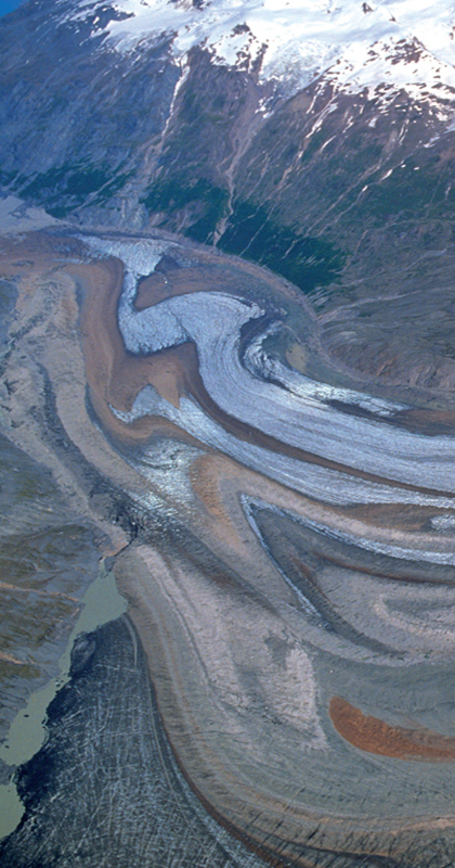
Figure 6.8 Flow folds in glacier ice, Lewis glacier, Alaska
Figure 6.9 Multilayer buckle folding
Figure 6.10 Fault-induced folding
Figure 6.11 Superimposed folding
Figure 6.12 Shear zones
Figure 7.1 Cleavage
Figure 7.2 A–C, cleavage fans; D, E, symmetric and asymmetric crenulation cleavage
Figure 7.3 Schistosity and gneissosity
Figure 7.4 Asymmetric fabrics: rotation and sense of shear
Figure 7.5 Asymmetric fabrics and shear sense
Figure 7.6 Lineations
Figure 7.7 A, intersection lineation; B, cuspate structure
Figure 8.1 Types of igneous intrusion
Figure 8.2 Methods of emplacement: dilational emplacement of dykes and sills
Figure 8.3 Dykes: some examples.
Figure 8.4 Granitic plutons of the Etive–Glencoe area
Figure 8.5 The Strontian pluton
Figure 8.6 Cone sheets of the Ardnamurchan Central Igneous Complex
Figure 8.7 Mode of formation of cone sheets, ring dykes and radial dykes
Figure 9.1 Gravitational instability of steep slopes
Figure 9.2 Gravity-gliding of Alpine nappes
Figure 9.3 Gravitational spreading
Figure 9.4 Evolution of a salt diapir
Figure 9.5 Salt structures in Iran
Figure 9.6 Flow directions and fold patterns in a salt diapir
Figure 9.7 Diapirism of granite-gneiss basement
Figure 10.1 An idealised collisional orogenic belt
Figure 10.2 Structure of the accretionary prism
Figure 10.3 Inversion
Figure 10.4 Channel flow
Figure 10.5 Terrane amalgamation
Figure 10.6 Oblique collision
Figure 11.1 The break-up of Pangaea
Figure 11.2 The Himalayan orogenic belt
Figure 11.3 Structure of the central Himalayan mountain belt
Figure 11.4 Velocity vectors of India relative to stable Eurasian plate
Figure 11.5 Alpine orogenic belts of the western and central Mediterranean
Figure 11.6 Cartoon cross-sections showing the evolution of the central Alps
Figure 11.7 Structure of the Swiss-Italian sector of the western Alps
Figure 11.8 The Canadian sector of the North American Cordilleran belt
Figure 12.1 Mid-Palaeozoic reconstruction of the continents
Figure 12.2 Main tectonic zones of the British-Irish Caledonides
Figure 12.3 Types of Caledonian structure
Figure 12.4 Cartoon sections showing the evolution of the British Caledonides
Figure 12.5 Tectonic zones of the Caledonides of the N. Atlantic region pre-Atlantic opening
Figure 12.6 Reconstruction of the continents of Laurentia, Amazonia and Baltica at ~990 Ma
Figure 12.7 The Canadian sector of the Grenville orogenic belt
Figure 12.8 Tectonic evolution of the Grenville orogenic belt
Figure 12.9 The Trans-Hudson orogen
Figure 12.10 Tectonic evolution of the Trans-Hudson orogen
Figure 12.11 The western Superior Province
Figure 12.12 Archaean terranes of the Nuuk area, southern West Greenland
Tables
Table 5.1 The Mercalli and Richter scales of earthquake magnitude
Table A1 The geological timescale
Table A2 Main types of igneous rock
Table A3 Some common types of sedimentary rock
Table A4 Some common types of metamorphic rock
Sourced illustrations
The following illustrations are reproduced by permission.
British Geological Survey. ©NERC. All rights reserved. IPR/73-34C: Figure 2.7
Jim Wark airphotos: Figures 5.6, 6.1, 6.8
NASA photo courtesy Space Images: Figure 2.1
NASA photo courtesy Parstimes: Figures 9.5A, B.
The following illustrations have been adapted from published sources.
Figure 2.2: Wyllie, P.J. 1976. The way the Earth works, Wiley, New York.
Figure 2.3: Hamblin, W.K. 1989. The Earth’s dynamic systems, 5th edition. Macmillan, New York.
Figure 2.5: Wyllie, P.J. 1976. The way the Earth works, Wiley, New York.
Figure 2.8: Zeuner, F.E. 1958. Dating the past (4th edn) Methuen, London.
Figure 3.2: Hamblin, W.K. 1989. The Earth’s dynamic systems, 5th edition. Macmillan, New York.
Figure 3.3: McElhinny, N.W. 1973. Palaeomagnetism and plate tectonics, Cambridge University Press.
Figure 3.6: Larson, R.L. & Pitman, W.C. 1972. Bulletin of the Geological Society of America, 83, 3645–3661.
Figure 3.7: Vine, F.J. & Hess, H.H. 1970, The Sea, Wiley, New York.
Figure 3.9A: Bott, M.P. The interior of the Earth, Arnold, London.
Figure 3.9B: Girdler, R.W. & Darracott, B.W. 1972. African poles of rotation. Comments on the Earth Sciences: Geophysics 2, (5), 7–15.
Figure 3.11: Uyeda, S. 1978. The new view of the Earth. Freeman, San Francisco.
Figure 3.12: Morgan, W.J. Deep mantle convection plumes and plate motions. Bulletin of the American Association of Petroleum Geologists, 56, 203–213.
Figure 3.13: Saemundsson, K. 1974. Evolution of the axial rifting zone in northern Iceland. Bulletin of the Geological Society of America, 85, 495–504.
Figure 5.4D: Reston, T.J. 2007. The formation of non-volcanic rifted margins by the progressive extension of the lithosphere: the example of the West Iberian margin. From: Karner, G.D., Manatscheal, G. & Pinheiro, L.M. (eds) Imaging, mapping and modeling continental lithosphere extension and breakup. Geological Society, London, Special Publications, 282, 77–110.
Figure 5.5A: Virtual Seismic Atlas, Robert Butler.
Figure 5.6: Reston, T.J. 2007 (see above).
Figure 5.7C: Elliott, D & Johnston, M.R.W. 1980. Structural evolution in the northern part of the Moine thrust zone. Transactions of the Royal Society of Edinburgh: Earth Sciences, 71, 69–96.
Figure 5.9B: Park, R.G. 1961. The pseudotachylite of the Gairloch district, Ross-shire, Scotland. American Journal of Science, 259, 542–550.
Figure 6.13: Ramsay, J.G. 1980. Shear zone geometry: a review. Journal of Structural Geology, 2, 83–99.
Figure 8.2C: McGregor, M.D. & McGregor, A.G. 1948. British Regional Geology: the Midland Valley of Scotland. HMSO, London.
Figure 8.2E: Nicholson, R. & Pollard, D.D. 1985. Dilation and linkage of en-echelon cracks. Journal of Structural Geology 7, 583–590.
Figure 8.4: Johnstone, G.S. 1966. British Regional Geology: the Grampian Highlands (3rd Edn). HMSO, London.
Figure 8.5: Hutton, D.H.W. 1988. Granite emplacement mechanisms and tectonic controls: inferences from deformation studies. Transactions of the Royal Society of Edinburgh: Earth Sciences, 79, 245–255.
Figure 8.6: Emeleus, C.H. & Bell, B.R. 2003. Scotland: the Tertiary volcanic districts. British Regional Geology, 4th Edition, London, HMSO for the British Geological Survey.
Figure 9.2: Graham, R.H. 1981. Gravity sliding in the Maritime Alps. From: McClay, K.R. & Price, N.J. (eds) Thrust and nappe tectonics. Geological Society, London, Special Publication 9, 335–352.
Figure 9.4: Trusheim, F. 1960. Mechanism of salt migration in Germany. Bulletin of the American Association of Petroleum Geologists, 44, 1519–1540.
Figure 10.1: Hatcher, R. & Williams, R.T. 1986. Mechanical model for single thrust sheets. Geological Society of America Bulletin, 97. 975–985.
Figure 10.2: Westbrook, G.K. 1982. The Barbados Ridge complex: tectonics of a mature forearc system. In: Leggett, J.K. (ed.) Trench-forearc geology: sedimentation and tectonics on modern and ancient active plate margins. Geological Society, London, Special Publications 10, 275–290.
Figure 10.4. Godin, L., Grujic, D., Law, R.D. & Searle, M.P. 2006.Channel flow, ductile extrusion and exhumation in continental collision zones: an introduction. From: Law, R.D., Searle, M.P. & Godin, L. (eds) Channel flow, ductile extrusion and exhumation in continental collision zones. Geological Society, London, Special Publication 268, 1–23.
Figure 11.1: Smith, A.G. & Briden, J.C. 1977. Mesozoic and Cenozoic palaeocontinental maps. Cambridge University Press.
Figure 11.2A. Molnar, P. & Taponnier, P. 1975. Cenozoic tectonics of Asia: effects of a continental collision. Science 189, 419–426.
Figure 11.3A, B. Harrison, T.M. 2006. Did the Himalaya crystallines extrude partially molten from beneath the Tibetan plateau? From: Law, R.D., Searle, M.P. & Godin, L. (eds) Channel flow, ductile extrusion and exhumation in continental collision zones. Geological Society, London, Special Publication 268, 237–254.
Figure 11.3D, 11.4: Searle, M.P, Elliott, J.R, Phillips, R.J. et al. 2011. Crustal-lithospheric structure and continental extrusion of Tibet. Journal of the Geological Society, London, 168, 633–672.
Figure 11.5A. Coward, M.P. & Dietrich, D. 1989. Alpine tectonics: an overview. From: Coward, M.P., Dietrich, D. & Park, R.G. (eds) Alpine tectonics. Geological Society, London, Special Publication 45, 1–29.
Figure 11.7. Ramsay, J.G. 1963. Stratigraphy, structure and metamorphism in the Western Alps. Proceedings of the Geologists Association 74, 357–392.
Figure 11.8A. Coney, P.J., Jones, D.L. & Monger, J.W.H. 1980. Cordilleran suspect terranes. Nature, London, 288, 329–333.
Figure 12.1: Dalziel, I.W.D. 1997. Neoproterozoic-Palaeozoic geography and tectonics: review, hypothesis, environmental speculation. Geological Society of America Bulletin, 109, 16–42.
Figure 12.3A: Elliott, D. & Johnson, M.R.W. 1980. Structural evolution in the northern part of the Moine thrust zone. Transactions of the Royal Society of Edinburgh: Earth Sciences, 71, 69–96.
Figure 12. 3B: Treagus, J.E. 2000. Solid geology of the Schiehallion district. Memoir of the British Geological Survey, HMSO.
Figure 12.3D: Leggett, J.K., McKerrow, W.S. & Eales, M.H. 1979. The Southern Uplands of Scotland: a Lower Palaeozoic accretionary prism. Journal of the Geological Society, London, 136, 755–770.
Figure 12.3F: Coward, M.P. & Siddans, A.W.B. 1979. The tectonic evolution of the Welsh Caledonides. From: Harris, A.L. Holland, C.H. & Leake, B.E. (eds) The Caledonides of the British Isles – reviewed. Geological Society of London, Special Publication 8, 187–198.
Figure 12.5: Dewey, J.F. & Shackleton, R.M. 1984. A model for the evolution of the Grampian tract in the early Caledonides and Appalachians. Nature, London, 312, 115–121.
Figure 12.6. Pisarevsky, S.A., Wingate, M.T.D., Powell, C. McA., Johnson, S., Evans, D.A.D., 2003. Models of Rodinia assembly and fragmentation. From: Yoshida, M., Windley, B., Dasgupta, S. (eds) Proterozoic East Gondwana: supercontinent assembly and breakup. Geological Society, London, Special Publication 206, 35–55.
Figure 12.7, 12.8: Rivers, T. The Grenville Province as a large, hot, long-duration collisional orogen: insights from the spatial and thermal evolution of its orogenic fronts. From: Murphy, J.B., Keppie, J.D. & Hynes, A.J. 2009. Ancient orogens and modern analogues. Geological Society of London, Special Publication 327, 405–444.
Figure 12.9, 12.10: Corrigan, D., Pehrsson, S., Wodicka, N. & de Kemp, E. 2009. The Palaeoproterozoic Trans-Hudson Orogen: a prototype of modern accretionary processes. From: Murphy, J.B., Keppie, J.D. & Hynes, A.J. 2009. Ancient orogens and modern analogues. Geological Society of London, Special Publication 327, 457–479.
Figure 12.11: Card, K.D. & Cieselski, A. 1986. DNAG#1: Subdivision of the Superior Province of the Canadian Shield. Geoscience Canada 13, 5–13.
Figure 12.12: Friend, C.R.L. & Nutman, A.P. 2005. New pieces to the Archaean terrane jigsaw puzzle in the Nuuk region, southern West Greenland: steps in transforming a simple insight into a complex regional tectonothermal model. Journal of the Geological Society, London, 162, 147–162.
Preface
This book is not intended to be a textbook, but is designed to explain the key concepts of tectonics and rock structures to both students and others interested in geology – especially those who may not have a good scientific or mathematical background. The study and understanding of geological structures has traditionally been guided by the rigorous application of mathematics and physics, and conventional textbooks on structural geology have reflected this approach. However, in my experience, many students are discouraged by this aspect of the subject and consequently, in this book, I have avoided mathematical equations altogether, and reduced the geometry to the minimum I judged necessary to understand the concepts. Those who wish to gain a deeper understanding of the subject, or who are engaged on a university-level course in structural geology, are directed to the reading list, which contains several excellent textbooks and on-line sources recommended for further study.
The application of plate tectonic theory has revolutionised structural geology by giving the study of structures a context in which they can be explained. Since the large-scale movements of the plates ultimately control smaller-scale structures, the study of tectonics is therefore the key to understanding the latter. I therefore introduce the reader first to large-scale Earth structure and the theory of plate tectonics. The following four chapters deal in rather more detail with what might be called ‘traditional’ structural geology – the study of the response of rock material to crustal forces, and the explanation for the bewildering variety of rock structures formed thereby. This aspect of geology was transformed in the 1950s and 1960s by rigorous geometrical analysis and the application of the techniques of rock mechanics. I believe that it is important for the student of geology to be aware of this background, without necessarily being able (at least initially!) to understand the mathematical or geometrical detail.
An important development in the latter decades of the last century was the emphasis by structural geologists on the movement history of rock masses relative to each other as revealed by the study of fault systems and shear zones. This enabled structural geology to be more directly related to plate tectonics and helped to integrate geological structures with tectonics; I have tried to emphasise this aspect in the book.
One of the most exciting aspects of geology is the study of the great mountain ranges (‘orogenic belts’), both of the present day and of the past. The final three chapters of the book attempt to explain how knowledge of plate-tectonic theory, geological structures and the processes of deformation may be employed to understand these orogenic belts.
Scientists are addicted to the classification and naming of the things that fall into their domain, and structural geologists are no exception. However, I have tried to avoid the excessive use of terminology, and all technical terms are defined and explained in the Glossary, which readers are encouraged to check when uncertain of the exact meaning of a word used in a geological context (which often differs from its everyday meaning!).
The Appendix contains a set of four tables that set out in a simplified way the main terminology of the geological timescale and of igneous, sedimentary and metamorphic rocks as an aid to those readers who may not be so familiar with these aspects of the subject.
Finally, I hope that the reader might share the excitement of discovering how the all-embracing theory of plate tectonics can help to explain the multitude of complexities revealed in the study of the rocks.
R.G.P.
December 2011
Note: all terms highlighted in bold are defined in the Glossary at the end of the book.
1Introduction
Meaning and scope of the terms ‘tectonic’ and ‘structure’
The adjective ‘tectonic’ merely means ‘structural’, i.e. applying to a structure. However, in geological usage it has come to be applied particularly to large-scale structures – thus ‘tectonic plate’. In order to explain rock structures, it is necessary to understand the forces operating within and on the crust that are responsible for creating them, and to do this, we need to investigate the Earth-scale processes known collectively as plate tectonics.
The term ‘structure’ in everyday usage refers normally to a building or other artificial construction, but in geological terms it has come to mean a body of rock whose shape can be defined geometrically and which has originated by a geological process. The most obvious and best known types of geological structure are folds and faults, which have been produced by the action of geological forces within the Earth’s crust and which can give us an insight into the magnitude of these forces and how they operate. Another group of structures is typical of deep-seated metamorphic rocks where crustal forces have effected thoroughgoing changes in the rock, producing new textures through recrystallisation; the structure produced by such changes is known as the fabric. A fourth category of geological structures consists of igneous intrusions. Such bodies are influenced by the forces acting within the crust during their emplacement and the igneous bodies themselves may cause structural changes in the host rocks.
Kinematic and dynamic models of deformation
Kinematics is the study of movement and dynamics the study of forces, and both types of model have been used in the investigation of geological structures. Dynamic models have traditionally been used by structural geologists employing the techniques of mechanical engineering and materials science. This requires a familiarity with mathematics and physics, which is a potential barrier to understanding for many students. However, whereas a background in these subjects is essential to understanding the deformation of rock in any depth, it is not really necessary to be able to grasp the essentials of structural geology at a basic level.
The kinematic model of deformation has become in many ways more popular as a way of understanding geological structures. In this type of approach, structures are analysed in terms of the relative movement between blocks of crust, and the causal forces are disregarded. Thus, systems of related folds and faults are explained by a single set of relative movements. Such a system can also be integrated into the plate tectonic model by scaling up to a higher order of magnitude but maintaining the same overall movement sense. Examples of this are discussed in Chapters 10–12, where we look in detail at the structure of orogenic belts. At this larger scale, structures are grouped into tectonic regimes, based on their over-riding characteristics, and linked with their plate tectonic setting, thus: extensional regimes are associated with divergent plate boundaries (continental rift zones); compressional regimes with convergent plate boundaries (subduction and collision zones); and strike-slip regimes with transform faults. These plate boundary types are explained in Chapter 3.
Layout of the book
The sequence of chapters reflects the author’s belief that an understanding of the plate tectonic model and the evidence for it is helpful in the understanding of geological structures on the smaller scale. Thus Chapters 2–3 deal with large-scale Earth structure and the theory of plate tectonics. These chapters are followed by chapters 4–9 on the process of deformation and on the various types of geological structure. Finally, Chapters 10–12 deal with the study and understanding of orogenesis and orogenic belts. A brief summary of each chapter follows.
 Chapter 2: Large-scale earth structure. This chapter describes the most significant features of the Earth’s crust: the continents and oceans, mountain belts, ridges and trenches; with the Earth’s internal structure, the asthenosphere and lithosphere; and finally with the distribution of present-day tectonic activity in the form of earthquakes and volcanoes.
Chapter 3: Plate tectonics. Modern plate tectonics starts with the theory of continental drift, which, when added to the more recent concept of ocean-floor spreading, led in the 1960s to the development of plate tectonics. The concept of the tectonic plate is explained, together with the three types of plate boundary – ocean ridges, ocean trenches and transform faults – and the processes that accompany them. This is followed by a brief discussion of hot spots and plumes, and finally by a consideration of the driving mechanism of plate motion.
Chapter 4: Deformation, stress and strain. This chapter deals with the processes that govern how structures are formed, and with the methods by which the amount of deformation (the strain) can be measured. The study of deformation requires an understanding of the relationship between force and stress, and between stress and strain. The various types of strain and the methods of measuring strain are discussed, followed by a consideration of the behaviour of rock material under varying conditions of temperature and pressure in response to stress.
Chapter 5: Fractures, faults and earthquakes. The description and geometry of faults and fault systems, and their relationship to their tectonic setting, are described first. This is followed by a discussion of the conditions under which fracturing, and thus faulting, takes place, and the relationship between faulting and earthquakes. Knowledge of how and why earthquakes occur is particularly relevant in today’s world – afflicted as it is by so many recent natural disasters with a geological origin.
Chapter 6: Folds and folding. This chapter deals first with the description and significance of the various types of fold structure in terms of their shape and mode of formation, and examines the nature and geometry of the strain accompanying each. This is followed by a discussion of fold systems, the three-dimensional geometry of folds, and fold superimposition. Shear zones are discussed here as a special case of folding, although they are in reality the deep-seated equivalent of faults. The chapter concludes with a discussion of the conditions under which folding occurs.
Chapter 7: Fabric. The effects of higher temperature and pressure are revealed in metamorphic rocks by special types of structure as well as by the changed mineral composition. These new structures include planar structures (foliation), new rock types, such as schist and gneiss, and new linear structures (lineation); these are included under the general term ‘fabric’. The effects of deformation under these conditions are to form structures that penetrate throughout the whole rock, unlike folds or faults, and involve micro-structural changes at the scale of the single crystal. Study of the fabric can reveal useful information about the deformation process accompanying the metamorphism.
Chapter 8: Igneous intrusions. Igneous intrusions are rock bodies whose shape is controlled by the state of stress (or force field) of the crust into which they have been emplaced; the different types of igneous body are thus of structural significance. Moreover, the process of emplacement itself exerts some structural control on the host rocks and produces structures in them. There are important differences between the structures of small-scale bodies such as dykes and sills and the large bodies (plutons) such as batholiths, laccoliths and lopoliths. Certain plutonic bodies are emplaced passively, by the host rocks moving aside to accommodate them, while others are forcefully emplaced by a mechanism termed diapirism, driven by gravitational pressure. Certain igneous complexes representing the roots of large central volcanoes consist of several different types of igneous body (ring dykes, cone sheets and radial dykes) that are related to each other by the stress field generated by the central magma body. Examples of these are described from western Scotland.
Chapter 9: Structural effects of gravity. The force of gravity has a key influence on deformation, and this chapter explores how gravity controls structures, giving examples of its effects in terms of gravity sliding on both small and large (orogenic) scales, and on the emplacement of salt domes.
Chapter 10: Tectonic interpretation of orogenic belts. This chapter explains how the principles of tectonics and structural geology are used in understanding present-day and ancient mountain belts.
Chapter 11: Examples of modern orogenic belts. Three typical examples are chosen from the present-day orogenic belt system: the central Himalayas, the Western Alps and the Canadian sector of the North American Cordillera. In each case the structure of the belt is explained in terms of its plate-tectonic context, and the sequence of plate movements that are believed to be responsible.
Chapter 12: Ancient orogenic belts. The same approach as in the previous chapter is taken to examples of more ancient orogenic belts – the Lower Palaeozoic Caledonides of the British Isles, the Mid-Proterozoic Grenville belt, and the Early Proterozoic Trans-Hudson belt of Canada. Finally, examples of Archaean orogenesis from Canada and Greenland are examined to explore the question of whether plate tectonics and orogeny operated in a basically similar way in the very distant geological past.
Appendix. There are certain topics of general geological interest, but not directly relevant to structural geology, which most geology students will understand, but which might be unfamiliar to other readers. These include the geological timescale, and the classification of igneous, sedimentary and metamorphic rocks, which are often useful in understanding the tectonic context of certain structures; these are summarised in the form of tables.
What is not included
This book is not intended as a comprehensive survey of the whole subject, and what is selected partly reflects the author’s subjective view of what is most important, and also a desire to keep the book reasonably short. Certain topics are omitted as not directly relevant; these include the interpretation of geological maps – the complex geometry of the interaction between simple structures and the three-dimensional ground surface – and sedimentary structures, i.e. bedding and allied structures formed by the processes of erosion and sedimentation.
2Large-scale earth structure
If we were to view the Earth from Space (Figure 2.1), the most obvious large-scale features would be the continents, the oceans, and the rather linear continental mountain ranges of the Alpine– Himalayan belt and the circum-Pacific belt, which includes the Cordilleran– Andean chain of the western Americas (Figure 2.2). Were we to imagine the water of the oceans removed, another set of mountain ranges would appear in the form of the ocean ridge network, which takes up around one-third of the oceanic surface area. Deep-ocean trenches would also be apparent, although these are an order of magnitude smaller in areal extent. They form a discontinuous system of linear features parallel to and offshore from island arcs, as in the NW Pacific, or close to the continental margin of western America. These large-scale structures are not randomly arranged but have a tectonic significance, being caused by geological processes that have operated over long periods of geological time.
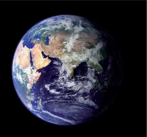
Figure 2.1 Earth from space. This photograph shows clearly the continents of Africa, India and much of Asia. The Alpine–Himalayan mountain belt can be faintly seen extending from between the Black and Caspian seas in the top west part of the globe running through the Zagros mountains north of the Persian Gulf and into Pakistan. The Himalayas are lost beneath cloud. NASA photo, courtesy Space Images.
Mountain belts, ridges and trenches
The most prominent and tectonically active mountain ranges form two linear belts shown in red in Figure 2.2. The Alpine–Himalayan belt extends from Gibraltar, through the Alps, Caucasus, and Zagros ranges, and culminates in the huge mass of the Himalayas and related ranges that sweep around northern India southwards to the Indian Ocean. The eastern side of the circum-Pacific belt chain follows the western margin of the Americas from Alaska down through the North American Cordillera to the Andes of South America. On the western Pacific margin, it forms a discontinuous chain including south-east Siberia, Japan and New Guinea. These belts vary considerably both in width and height: the width of the western American belt is over 600 km in the Canadian Rockies but only around 400 km in the southern Andes. The Alpine– Himalayan belt is even more variable: it divides into several branches around the Mediterranean, including the Atlas and Apennine ranges; in central Asia, the belt broadens to around 1500 km where it surrounds the high plateau of Tibet. Ongoing tectonic activity in these belts is expressed by sporadic volcanism and frequent earthquakes. Other prominent mountain belts, such as the Urals, Caledonian and Appalachian ranges, are no longer tectonically active, being the result of processes in more remote geological periods.
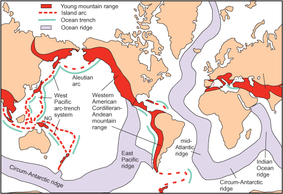
Figure 2.2 Main topographic features of the continents and oceans. The young mountain ranges form two distinct belts, the Alpine– Himalayan and circum-Pacific, meeting in Indonesia. The western part of the circum-Pacific belt consists of partly submerged mountain ranges. The ocean ridges, which are almost entirely submerged, form a continuous network extending through the mid-Atlantic into the Antarctic where it meets the Indian Ocean ridge, and continues into the Pacific, where it ends against the coast of Mexico. The much narrower trenches lie offshore of western America and also parallel to a series of island arcs around the north and west Pacific Ocean and off Indonesia in the Indian Ocean. Smaller arcs are located in the Caribbean and south of S. America.
The ocean ridges, shown in blue on Figure 2.2, are even more prominent features than the mountain belts in terms of their volume, although of course almost entirely hidden below sea level; they are typically 500–1000 km wide and elevated by as much as 2–3 km from the deep ocean floor. The ridge network consists of three main strands: the Mid-Atlantic, Indian Ocean and circum-Antarctic ridges, the latter extending through the southeast Pacific Ocean to end against the North American coast off Mexico.
The deep-ocean trenches (thin green lines on Figure 2.2) are much smaller features than the ridges, being only about 100–150 km across, but they attain depths of up to 11 km below sea level. They fall into two groups: those of the first group lie offshore from, and parallel to, the western continental margin of the Americas, and those of the second group form a discontinuous series of curved features parallel to the volcanic island arcs of the western and northern Pacific Ocean and south-west of Indonesia in the Indian Ocean. Smaller arcs are located in the Caribbean and between South America and Antarctica.
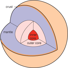
Figure 2.3 The cutaway model shows the main regions of the Earth’s interior: solid inner core, liquid outer core, mantle and thin crust.
Earth’s internal structure
A considerable amount is known about the internal structure of the Earth, much of it from the study of earthquake waves. On the scale of the whole Earth (Figure 2.3) the crust represents only a thin outer shell with an average thickness of around 20 km. The bulk of the Earth is made up of the mantle, the base of which lies at a depth of 2900 km below the surface, and is composed largely of solid material with a composition similar to the igneous rock peridotite. It is here that the processes that mostly control what happens at the Earth’s surface originate, as we shall see in the following chapter. The innermost, approximately spherical, region is called the core, and extends to the centre of the Earth, at 6500 km depth. The core is believed to consist mostly of metallic iron, with some lighter elements in addition, such as nickel. In the outer core the metal is in a molten state but the inner core is solid. These constituents are thought to have become molten at an early stage in Earth’s history and drained down towards the centre, forming the core.
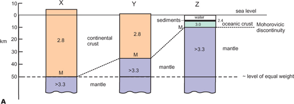
Figure 2.4 A. Structure of the Earth’s crust. Average cross-sections through thickened continental crust (X); mean continental crust (Y); and oceanic crust (Z); note that the extra height of the continental sections is compensated by their reduced density so that the total weight of each is equal at 50 km depth.
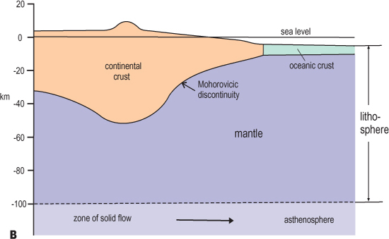
Figure 2.4 B. Structure of the Earth’s crust. Schematic cross-section showing how the crust varies in thickness; differences in mantle thickness within the lithosphere are compensated by lateral flow within the weaker asthenosphere.
The nature of the crust
The crust varies in thickness from about 7 km beneath the oceans, to an average of about 33 km in continental areas, and reaches nearly 80 km in depth beneath certain young mountain belts (see Figure 2.4). The composition of the crust is known in some detail, since material from the various depths of the crust is directly accessible at the surface somewhere because of tectonic movements. There is a great difference between oceanic and continental crust; oceanic crust is composed almost entirely of the volcanic rock basalt, whereas continental rocks are extremely varied in composition, including the whole range of igneous rocks together with all the different types of rock derived from them. However, the average composition has been estimated to be similar to a mixture of granite and basalt.
The present-day coastlines are arbitrary, in the sense that sea level fluctuates through time in response to various geological processes. The formation or removal of ice sheets and the uplift or depression of land masses cause either the retreat or advance of the shorelines across the continental margins. The true margin of the continents may be taken as a line about halfway down the continental slope, where the nature of the underlying crust changes from continental type to oceanic type (Figure 2.5). Measured in this way, the ‘continents’ would occupy around 40% of the Earth’s surface area rather than less than the 30% that currently consists of land. Looking in more detail at the Earth’s surface, it becomes apparent that a large proportion of it consists of either plains or plateaux on land, or the deep-ocean floor; these show little variation in relief until interrupted by the extreme elevations and depressions of the mountain ranges and deep sea trenches, which occupy only about 3% of the surface area. Between these two dominant levels is a region of intermediate depths, amounting to perhaps 15% of the total area, representing the continental slopes and the ocean ridges. The reason for this distribution, as we shall see, is that the zones of high relief result from localised tectonic instabilities, whereas the areas of low relief are more stable.
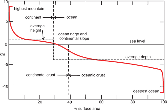
Figure 2.5 The hypsographic curve. This graphical representation shows the variation in surface height (and depth) in terms of the proportion of surface area occupied; there are two large parts of the graph corresponding respectively to continental plains and deep ocean, with a transitional part representing the continental slopes and ocean ridges; areas of extreme relief (mountain ranges and ocean trenches) occupy a very small part of the total.
The differences between continental and oceanic areas are due to differences in the composition, and consequently the density, of the underlying crust, as shown in Figure 2.4. Continental crust, with a composition corresponding to a mixture of granite and basalt, has a mean density of around 2.8, whereas oceanic crust, composed largely of basalt, has a mean density of around 2.9. Moreover, continental crust has a mean thickness of about 33 km and oceanic crust is much thinner, averaging only about 7 km. This explains their difference in mean height (or depth) with respect to sea level. Because the Earth is in a state of approximate gravitational balance (termed isostasy), the weight of any particular sector is similar to that of any other. Consequently, the less dense continents must attain a higher level than the denser oceans if they are to have the same gravitational effect (i.e. have the same weight). In other words, we can imagine the continents as being more ‘buoyant’ than the oceans, as if they were icebergs floating on the sea. Although the mantle underlying the crust is made up of solid rock (approximating to peridotite in composition), it is able to flow in the solid state at a very slow rate of centimetres per year, enabling it to gradually adjust to the pressure of gravitational differences in the crust above. Thus, when a particular part of the crust is subjected to an additional load, by the creation of a mountain range for example, its base adjusts by sinking downwards and displacing mantle material sideways to form a ‘mountain root’ as shown in Figure 2.4B; like an iceberg, much more of the volume of the thickened crust of a mountain range lies beneath sea level than above! The reverse happens when crust is thinned to form an ocean basin, for example; the top of the mantle rises and the surface is depressed, but the whole is still in gravitational balance.
Asthenosphere and lithosphere
The region of the mantle in which flow takes place lies at a depth of about 100 km beneath the surface, and is termed the low velocity layer because of the fact that seismic waves travel more slowly through it than would be expected if it were composed of normal mantle material, indicating that its density is lower than that of the surrounding mantle. It is therefore regarded as a zone of relative weakness and is termed the asthenosphere (see Figure 2.4B). The region above this level, composed partly of mantle and partly of crust, is stronger and is termed the lithosphere. As we shall see in the next chapter, it is the lithosphere from which the tectonic plates are formed, and their ability to move across the Earth’s surface is due to the relative weakness of the underlying asthenosphere.
Present-day tectonic effects: earthquakes, volcanoes and aseismic movements
The Earth is subject to continuous tectonic activity, as testified by the occurrence of earthquakes (seismicity) and vulcanicity of varying severity, much of it with disastrous consequences. This activity is not random but is concentrated in well-defined zones (Figure 2.6).
Earthquakes
Although earthquakes can occur almost anywhere, the great majority of them (and all the most severe ones) are concentrated in narrow zones along the centres of the ocean ridges and in a rather wider zone along the Alpine–Himalayan and circum-Pacific mountain belts delineated in Figure 2.2. The earthquakes along the ocean ridge network are generally quite shallow, less than ~50 km in focal depth, but those near the ocean trenches range from shallow to deep – up to 700 km in depth, indicating that the tectonic process responsible for the latter is different. The earthquakes along the young mountain belts are intermediate between the two extremes, generally lying above about 300 km. The reason for these differences will become apparent when we discuss plate tectonics in the next chapter.
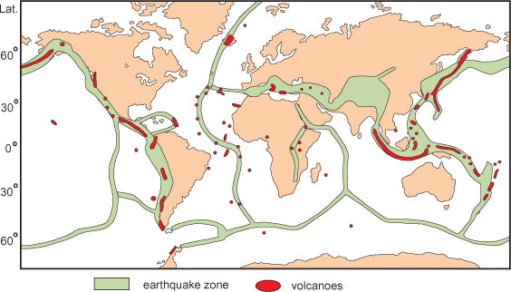
Figure 2.6 Pattern of recent earthquake and volcanic activity. The majority of earthquakes follow well-defined narrow zones along the centres of the ocean ridges and rather broader zones along the Alpine–Himalayan mountain ranges, the island-arc network and the western Americas belt. Most of the volcanoes lie within these same zones, but some oceanic volcanoes are situated away from the ridge crests, especially in the Atlantic ocean.
Volcanoes
The distribution of vulcanicity, like that of earthquakes, is distinctly non-random; there are three main categories of occurrence. The majority of active volcanoes are concentrated along the circum-Pacific and Alpine–Himalayan belts, as shown in Figure 2.6; secondly, there are numerous occurrences along the ocean ridges and on subsidiary ridges within the ocean basins, as well as in Hawaii. A third category is associated with continental rift zones such as the African rift valley. There are characteristic differences in the type of lava emitted from these volcanoes – oceanic vulcanicity is typically basaltic whereas that associated with the circum-Pacific and Indonesian belts is dominated by andesitic vulcanicity. The reasons for both the distribution and the compositional difference are explained by the plate tectonic theory to be discussed in the following chapter.
Aseismic tectonic activity
Crustal movements currently taking place can be measured by repeated recording of location and height using sensitive instruments. The larger and more obvious movements are associated with the major tectonic belts already recognised from their seismic and volcanic signatures, but less intense movements can be recorded well away from these belts anywhere on the Earth’s surface. These movements are generally not accompanied by earthquake activity, that is, they are aseismic and show both horizontal and vertical movements of the order of millimetres to centimetres per year.
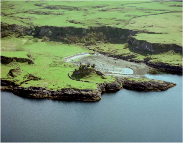
Figure 2.7 Raised beach. The wave-cut platform in the foreground on which the castle now stands has been raised about 5 m above present-day sea level due to post-glacial uplift; the raised beach is backed by a cliff that would have originally represented the shore line. Lismore, Argyllshire, Scotland; IPR/73-34C British Geological Survey © NERC.
Relatively recent vertical movements of the land surface relative to sea level can also be studied by observing the positions of raised beaches (e.g. Figure 2.7) and buried forests. This evidence shows us that since the last (Pleistocene) Ice Age, the land surface of Scotland and Scandinavia has been uplifted due to the slow recovery after the release of the weight of the ice sheet. In the case of Scandinavia, the old shore-line has been uplifted into a dome-like shape by up to 250 metres (Figure 2.8); this gives average uplift rates of up to 10 millimetres per year. Larger post-glacial uplift rates for Iceland have been calculated in the range 2–9 centimetres per year.
cratons‘mobile’ beltsArchaean