
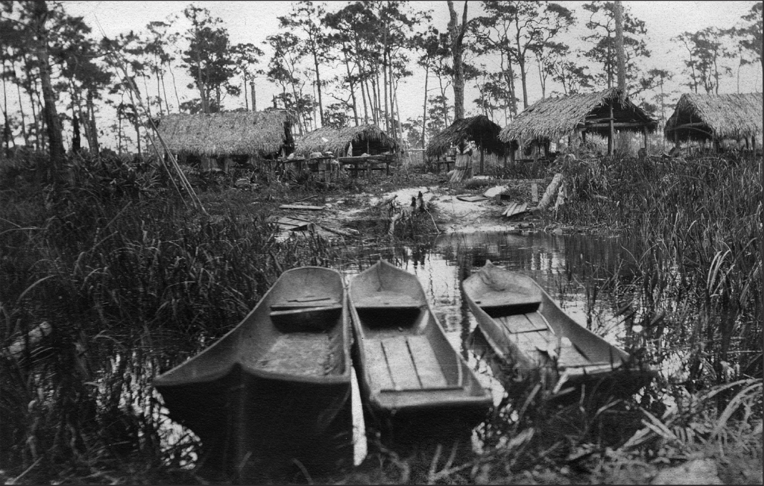
Another view of the Seminole camp is on pages 10-11. (Historical Society of Palm Beach County)
DEDICATION
INTRODUCTIONS
PRELUDE
MUCK, MIRE AND MAGNIFICENCE
1875: A little girl’s letter from Florida / A helicopter ride over Palm Beach County / The eastern ecosystem / The western mucklands and how they were formed / The phenomena of soil subsidence / The land of 10,000 years ago / The Calusa and the Spaniards / English rule / Seminole farmers in the Everglades.
CHAPTER 1
LAKE WORTH: THE GARDEN OF EDEN
1845: Florida becomes a state / The Jupiter Lighthouse settlement spawns Lake Worth’s first pioneers / When copper and brass were a beachcomber’s ‘crops’ / When ‘farming’ meant pumpkins and potatoes / Shipping tomatoes by sailboat / Pineapple fever: a cash crop at last / Turn of the century: a pinch of prosperity / Flagler: the man who changed Palm Beach County forever / Farms and packinghouses follow the railroad south / A Boca Raton farmer’s diary.
CHAPTER 2
EVERGLADES: THE LAST FRONTIER
Tracking through the sawgrass wilderness / 1885: Hamilton Disston and the first effort to ditch, drain and dry the swamplands / A heart gets its arteries: the big canals / The catfish and sawgrass economy / 1910: the first ‘real’ farmers – and first land sales boom / Founding of Chosen, Belle Glade and Pahokee / Sugar puts down its first roots / A whiff of science and technology / 1925: The second great land boom.
CHAPTER 3
BOOM, BUST, BLAST AND BEWILDERMENT
The real estate collapse of 1926 / The 1926 hurricane: a jolt of Florida reality / Drying out: the rush to replant / A farmer’s apocalypse: the 1928 hurricane / 1929: another burst of incorrigible hope / The Depression: a man-made disaster / A renewed effort to protect farmers: building of the Hoover Dike / Late thirties: the dawn of corporate farming / World War II: taking the wraps off farm production.
FACTS AND FIIGURES ABOUT AGRICULTURE IN PALM BEACH COUNTY
CHAPTER 4
POSTWAR: FIELDS OF DREAMS, FLOODS OF FRUSTRATION
U. S. Sugar’s early struggles / The 1947 hurricane and aftermath / The ‘Milk Trail’ of dairies on Military Trail / Nurseries: from bouquets to bougainvillea / The sandy soils: peppers, tomatoes and packinghouses / ‘Beef County’, or how we nearly closed Texas / How research built better turnips and fatter calves / Cattlemen who made the Glades bustle.
CHAPTER 5
1960-1980: WHEN CANE BECAME KING
Beans, celery and salad greens / Sugar fever: it wasn’t all spiked by Castro / The U. S. sugar program and how it works / An oasis of citrus: the story of Callery-Judge / The East: dairies feel the squeeze of urban development / How nurseries filled in the eastern gaps / Milestones in Muckland: the Glades weathers labor woes, but sees rise of corn, rice, scientific farming, better marketing and mechanized harvesting.
CHAPTER 6
AGRIBUSINESS IN THE AGE OF WAL-MART
The environmental onslaught / Cattle: the last roundup as herds are driven north / Citrus: a sticky business in light of changing consumer demands / The Age of Consolidation / Sod: A little Everglades in every backyard / The Consumer Age / The Supermarket Age / How specialty growers still farm under the big business radar.
CHAPTER 7
QUESTIONS FOR FARMING’S FUTURE
Should farmers be made to go away? / Can farmers afford to stay in business? / Will Mother Nature continue to allow farming? / Will it be in Palm Beach County?
ENDNOTES
SOURCES AND RESOURCES
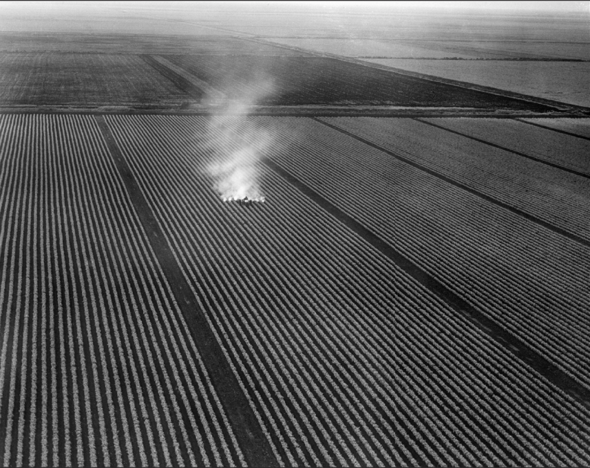
Just 25 miles west of the Florida Turnpike, a crop sprayer plies its way across a seemingly endless carpet of row crops. A century ago it was a thicket of impenetrable sawgrass. (Historical Society of Palm Beach County)
Marion Geer tried to put in prose just what made her parents seek their elusive “Garden of Eden” somewhere in Florida.
Our home had been on an Illinois farm. And when one has experienced the sort of weather that this and other northern states are capable of;
When the mercury has taken up winter quarters at the bottom of the tube;
When the windows are so coated with frost that looking out is impossible for days;
When the winds come sweeping over the prairie, gathering force with every mile, shaking doors and windows, shrieking and howling around corners as though a host of demons had been let loose;
When the blinding snow storms come, blocking roads, burying fences out of sight; And when at last spring comes with its interminable mud, deep, black and sticky, the climax has been reached and the desire for a change to a more genial locality cannot be wondered at. 1
The year was 1875, and little Marion might have been writing on behalf of the millions of migrants who would follow her family to Florida. In December, three Illinois farm families with 13 members packed all their belongings and took a grueling 78-hour, 1,300-mile train ride to Jacksonville. There they’d rent a house while the men folk headed south on a scouting trip to find the fairest farmland in Florida.
But already the contrast was breathtaking, even in the state’s northernmost city. “It took us a long time to realize that we needn’t bundle up nor shiver when we went out of doors,” wrote Marion in 1896, then a woman looking back on her girlhood. “Nor to realize that it was no longer necessary to put our vegetables to bed to keep them from freezing, nor thaw out bread, meat and milk each morning before the family breakfast could be served.
“After months of wandering,” recorded Marion, “they returned [in the summer of 1876] declaring with one accord that at Lake Worth, 300 miles south of our temporary home, they had found the Garden of Eden, where the sky was bluer, the water clearer, the flowers sweeter and the song of birds more musical than could be found elsewhere on the continent.”
More later on what actually awaited them.
The legacy left by those first farmers after a mere two or three generations is an awesome sight today. You can’t really grasp it all from the ground. Most of us don’t know Palm Beach County much beyond our gated communities, golf clubs and nearest shopping centers. For some, our most expansive horizon is that strip of asphalt, lawns, streets and parking lots east of the Florida Turnpike. Within that stretch of land a thousand family farms have already been paved over or planted with homes and truckedin trees.
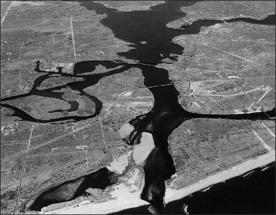
To the northeast of Lake Okeechobee lies a separate ecological system, the 400- square-mile Loxahatchee River Basin. The marshy sloughs surrounding the Loxahatchee also feed the St. Lucie River and Indian River estuary. (Historical Society of Palm Beach County)
But there’s still much, much more to see in this vast county. Let’s go to Boca Raton’s small airport and board a helicopter. We’re about to survey in one quick loop a county that, at 2,578 square miles, is twice the size of Rhode Island and more than half as large as Connecticut.
As we lift off, heading north, we see more familiar sites on the right: Atlantic Avenue, Boynton Beach Boulevard – linked to I- 95 – then the 23-mile-long Lake Worth Lagoon, spangled with bright flecks and surrounded with homes and Caribbean blue pools. Only a few preserves of flatwoods and scrubland dot the landscape – remnants rescued in an Atlantic Ridge where cattle once roamed and pineapples grew.
Now look down to the left where the turnpike stretches. It’s still a land in transition. Here, a golf course lined with Addison Mizneresque McMansions with zero lot lines. There, a forty-acre tomato patch, a ten-acre nursery, an equestrian center, an unkempt tract full of scruffy native trees – all perhaps awaiting that visit from a developer with his cashier’s check to the Promised Land.
Beyond Northlake and PGA Boulevards looms the upper Loxahatchee Slough, part of the soggy 400-square-mile watershed that feeds the Loxahatchee River with its hundreds of rivulets and many canals. Beyond it a tea-colored ribbon, the river itself, its upper reaches girded by the 11,000-acre Jonathan Dickinson State Park. Every day the Loxahatchee loses a bit more in volume as it competes with new golf courses and housing developments, their pipes sucking into the aquifer below like so many straws in a milk shake.
Now we swerve left and west. Past the vast Pal-Mar and J. W. Corbett sanctuaries – all part of the separate eastern ecosystem. We see the eastern rim of Lake Okeechobee and the green hump of the Herbert Hoover Dike that girds most of it. We’re soon in the ecological orbit of the nation’s second largest body of freshwater, a 468,680-acre saucer that is divided like a pie by five counties.
As we begin a swing to the southwest, we see what 90 percent of the county’s population never visits: a vast green, nearly level landscape that stretches even beyond a helicopter’s horizon. We’re now fluttering over part of the 707,000-acre Everglades Agricultural Area, an endless array of green and black rectangles of sugar cane, sweet corn, lettuce, celery and other crops. Thousands of miles of man-made ditches crisscross the landscape, most of them draining eventually into the West Palm Beach, Hillsboro and North New River Canals. Crossing the canals are two rail lines for hauling crops to market. Moving down the roads below like soldier ants are large trucks bringing sugar cane to mills whose stacks billow white steam around the clock from October through May. Other trucks make their way to supermarket distribution centers with branded vegetables, shucked, sliced, diced and packaged conveniently for families on the run.
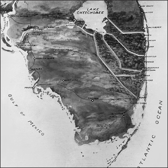
This map was drawn in 1924 to show the five major canals that had been dug to drain and “tame” unruly Lake Okeechobee. (Florida State Archives)
We’re now approaching Belle Glade, strictly a farm worker’s town, the largest in the Everglades, sprawled smack dab in the black soil that gives it the nickname, “Muck City.” A popular restaurant is the Black Gold Steak House and the biggest event is the annual Muck Bowl between Glades Central and Pahokee high schools. “Welcome to Belle Glade. Her Soil Is Her Fortune,” read the highway signs on the edge of town.
Locals like to tell about two farm boys in the thirties. They were planting corn one morning and discovered that it was sprouting immediately behind them. Seems that one boy shouted over his shoulder that the other should sit on some of the seeds so they wouldn’t grow to fodder before they finished planting. Well, before long the seed sitter had vanished. The next day the other boy heard a clunk and picked up a rock with a note wrapped around it.
“Passed through Heaven yesterday at noon,” it said. “Sellin’ roastin’ ears to angels.”
The exuberance of stories and slogans like these belies one little problem of Belle Glade and environs. They are slowly, surely, sinking – perhaps into oblivion.
Muck was made for centuries as plants died, fell into shallow water and decayed. It slowly compacted as most of the remaining oxygen was “squeezed” out. The end product was a dense, dark, spongy, fibrous layer of material that lay atop the hard limestone that provides Florida’s bedrock. Problem is, the top layer of the muck is exposed to oxygen, and each year is oxidizes and subsides (shrinks) by an inch or so.
In 1924, when the Everglades Experiment Station was founded (it’s now the University of Florida Agricultural Research and Education Center), some far-sighted staff members hammered a concrete post down to the bedrock. At the time, the part that stuck out was nine feet. Ever since, this “muckometer,” like a doomsday clock, ticks down the inches to the hour when farming by current methods will presumably be impossible.
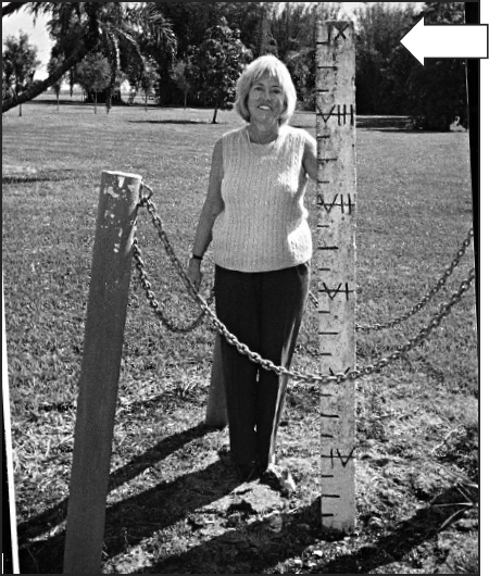
Today it’s known as the University of Florida’s Everglades Research and Education Center in Belle Glade. Back in 1924, when it began as UF’s Everglades Experiment Station, farsighted academics drove a stake nine feet down to the limestone bedrock to measure how the muck covering the surface would oxidize and subside over time. Director Christine Taylor Waddill shows that today’s soil level is barely over three feet above the bedrock, compared to nine feet (see arrow) eighty years ago. (Wayne A. Boynton)
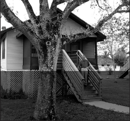
Dennis Wedgworth, representing the third generation to run Wedgworth Farms, poses on steps of the house his grandfather, Herman, occupied when he joined the Experiment Station in Belle Glade. At the time, the foundation of the house (shaded area) rested where the top of the latticework is today. (Sue S. Snyder)
So far it’s sunk nearly six feet as people cope and pray. Palm Beach Post columnist Michael Browning quotes a life-long resident as saying “Belle Glade is the only town I know of where people, if they have a few extra dollars, go out and buy a load of dirt to spread around their houses.” Indeed, as Browning adds:
Homes in Belle Glade built in the 1950s and 1960s wear aprons of dirt, shoveled in around their edges, hiding their foundations like middle-aged women hiding their petticoats. Certain sidewalks seem to float in mid-air. Older wooden houses look like daddy-longlegs spiders, perched on spindly pilings driven down to bedrock in the 1930s and ‘40s. In 1994, at the Belle Glade Cemetery, there was a virtual preview of the Last Judgment, with the above ground mausoleum starting to resurrect itself from the muck, and a gap of four to five inches yawning between its concrete slab and the surrounding soil.
The story of muck – and subsidence – has been unfolding since before the first Egyptian pyramid was built. So far it has been a miracle waiting to be worked by anyone who tills it. But to understand this agricultural miracle fully, one must look at the land long before it was discovered, disturbed, dammed, ditched, diked and drained by man.

Let’s look at the Lake Okeechobee ecosystem a thousand years ago. As today, it begins many miles north where a chain of lakes feeds the Kissimmee River. After 50 twisting miles, the Kissimmee flows into a huge pie plate that sits, almost as if sculpted from the limestone below, some 20 to 22 feet above the level of the ocean.
Balanced within this shallow pan is 730 square miles of water, 37 miles long from north to south and 32 miles across. Its depth averages twelve feet. But because the trek from the Kissimmee to the Florida Straits is an ever-so-slight decline, the water is always moving, pushing against the lake’s southern rim.
The rim is a natural levee, created by the buildup of soil and vegetation left as the lake spilled over and dried, year after year, century after century. As the muck dried and compacted, it became a berm against which the waters pushed and probed for an opening. At the rim, the muck is as deep as 15 feet, becoming shallower the farther one travels southward.
Along that rim, from due south at today’s Clewiston to Port Mayaca on the east, is an immense forest. Perhaps 32,000 acres of gnarled and crooked custard apple trees gird the lakeshore in a belt two miles thick. Blanketing their tops during most of the year is a leafy cover of moonvines. When the custard apples produce their big, cream-colored flowers and the moonvines deliver their blanket of white blossoms, and spider webs produce a garland of gossamer, a raccoon can scamper through the forest at noon and never see the sun. 2
To the east and north are flat sandy beaches. But behind them is a low, rocky ridge of limestone that all but prevents the lake from overflowing. Beyond it are several hammocks on “islands” of high ground. The soil is thin, the color of unpolished silver, for few spillovers have occurred and only the thinnest of muck layers formed. And so, the areas east and northeast of the lake have formed their own ecosystem, with stretches of pine, or cabbage palms or grassy prairies, crossed by numerous sloughs and marshes. Heavy summer rains still leave much of the land under water, giving rise to stands of cypress forest and thickets of sawgrass. When the water drains, it moves slowly eastward into the vast slough that feeds the Loxahatchee and St. Lucie rivers.
To the west of the lake is a low, wide, limestone barrier. It extends in a southerly direction almost parallel with the ridge running some forty miles to the east. With two ridges running south like wobbly tracks, the high water in the rainy season has nowhere else to go but to slap, century after century, at the southern rim of dried muck. The natural muck levee may be dense, but not like a limestone ridge. When the lake is brimming full, water trickles under the muck or spills through well-carved chinks and glides through the custard apple forest.
Beyond the forest are more than a dozen well-worn natural rivers and creeks that dead-end into a thicket of sawgrass. Most simply dissipate after two or three miles, but in the midst of the rainy season they can run a hundred feet wide and ten feet deep, flowing at two feet per second. The widest and deepest of these natural rivers will one day be attacked by dredges and given names such as the Hillsboro Canal, and North New River Canal.
Five or six miles south of the lake, the spill flow has blended into the Everglades. It is now roughly six feet above sea level, moving at a foot or so a minute through a forty-mile-wide belt of sawgrass, 5,000 square miles in all, as large as Connecticut. In some years it will eventually dissipate forty miles southward as it sloshes into another natural ridge that forms the foundation for today’s Tamiami Trail from Miami to Naples. In especially wet seasons, it will rise over the stubby ridge and flow for another forty miles or so into the Florida Straits.
Centuries later, humans would describe it as a “river of grass.”
For some 10,000 years the land was lived on by generations of Paleo-Indians, but seldom disturbed. Hunting, fishing and foraging for wild fruits were so bountiful that the Indian bands had no need to form villages or plant crops. Archeologists agree that they were probably divided into three cultures: the Glades to the southeast; the Belle Glade, centered around the lake; and the Caloosahatchee, from the southwest to the western coast.
But beginning around 1000 B.C. the Indians had organized into a network of small villages linked to a few large centers of civilization. Nearly 3,000 years later, during the Seminole Indian Wars, the army staked out a camp along Fish Eating Creek (ten miles from the lake’s west shore) and found itself amidst a series of earthworks that occupied more than a mile along the creek. When the first of several archeologists explored the Fort Center site in the 1920s, they found mounds, ponds, burrows, circular ditches and large linear embankments. A canoe canal linked the occupants with Lake Okeechobee.
Other centers were later discovered in the Belle Glade and Canal Point areas of Palm Beach County. At Big Mound City, northeast of Belle Glade, the embankments are formed in a huge semicircle or horseshoe pattern. Extending from the primary arc are several angular earthworks jutting out from the circle that average about 500 feet in length, each with a small oval mound at its end. Nearby are several miles of shallow canals made to speed canoe travel between villages and rivers.
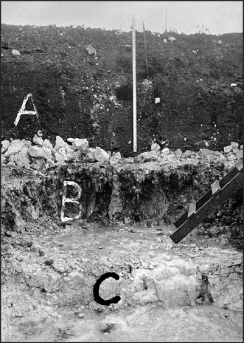
A cross section of earth photographed by the U.S. Soil and Conservation Service in 1943. ‘A’ is 4 feet of sawgrass muck at top and ‘B’ is Lake Flirt marl about 20 inches thick. C at bottom is the Fort Thompson Formation, or the limestone bedrock that underpins southern Florida. (Florida State Archives)
Since Fort Center was excavated for more than six years, it has yielded archeologists the most knowledge about early Indian sites. Ditches there, for example, may also have been used for draining fields of corn. One circular ditch was 375 yards in diameter, averaging 28 feet wide above the water level and 6 feet below it at the bottom. It had been built and added to since 450 B.C., according to carbon dating. Indeed, corn pollen was identified from soil samples. Some also speculate that muck was even collected and spread on the crops.
The Indian mounds were thrown up to provide flood protection, with a separate function – one, say, for a large dwelling, one for a burial place and another for a refuse dump. One scholar, Jerald T. Milanich, indicates that a platform was built atop one mound for a house where men conducted meetings and funeral rites.
[It was] made out of timbers, including inverted tree stumps placed underneath for support. Posts, the upper portions of which were carved in the shape of animals, helped to suspend the platform above the water level in the pond. The bottoms of the carved posts were pushed down and anchored into the pond bottom. Other carvings adorned the sides of the platform, on which bundles of human bones were laid after the bodies of the deceased had first been processed in the charnel house. At some point, loaded with the remains of 150 or so individuals, the platform was partially burned, and then it collapsed into the pond. 3
Indeed, the pond bottom would yield what Milanich called an “incredible array” of wooden carvings, including life-size cats, a bear, foxes, two larger-than-life eagles (see far right) and “an exquisitely fashioned running otter with a fish in its mouth.” Added the archeologist: “I believe that the building could have been a men’s lodge, where Belle Glade males lounged, chipped tools, smoked their pipes and carved the wooden platform supports. They also performed rituals and duties associated with caring for the dead.” 4
But the biggest surprise was what was among the top layers of the burial mounds. Spanish coins. Glass and metal beads. Pieces of brass from ships. Bracelets of gold and silver. Inca ornaments. Pendants of 24 karat gold. 5
How? Why? Let’s begin with the period A.D. 1200-1400, when carbon dating detects a new wave of earthwork activity around the Fort Center and Belle Glade sites. It coincides with the emergence of the Calusa as the dominant of the three Indian cultures. With a greater population, richer resources, and a tradition of strong chiefs, the Calusa were able to muscle the Indians of southern Florida into a confederation of villages and trading arrangements that extended from the mouth of the Caloosahatchee River at Charlotte Harbor to the mouth of the Loxahatchee River in Jupiter. 6
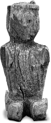
This kneeling cypress carving some say by a Calusa shaman, was discovered in Pahokee in 1928 by Karl Riddle, who was a construction engineer alter serving as city manager of West Palm Beach. (Historical Society of Palm Beach County)
By the time the Spanish showed up, they were confronting an entity with a spokesman and some political clout. In 1565 a shipwrecked Spanish sailor, one Escalante de Fontaneda, was rescued after living some twenty years among the Calusa. He described the Indians of “the territory of Carlos” [the chief] whom he described as “the greatest of kings, having the renown of Montezuma.”
The Calusa, said Fontaneda, are “brave and skillful. They are masters of a large district.” He singles out “a town they call Guacata [probably Fort Center] on the Lake of Mayaimi [Okeechobee] because it is very large. Around it are many little villages.” Fontaneda gave the names of 22 and apologized for omitting “twenty towns more whose names I do not remember.” One might anticipate that the Spanish would come to south Florida with cattle, horses and a variety of seeds for the beginnings of agriculture. They did not because they hadn’t done so since the founding of St. Augustine in 1565. 7
Had the Spanish a chance to spend much time in Lake Okeechobee and study its soil, they might have coveted black gold instead of precious metals. But it was not to be. By the time Pedro Menéndez de Áviles arrived in St. Augustine as governor, he had already failed to find gold and silver except for what his men could extract from the holds of shipwrecked galleons.
Menéndez’ best hope for redemption from the crown lay in converting Indian souls to Christianity and finding an exportable crop that would fetch high prices in the markets of Madrid. But the deck was stacked against him on both counts. First, the colony was constantly on the brink of starvation, meaning that it quickly devoured the grain, seeds, cattle and pigs that had been brought aboard ship to begin agriculture on the new continent.
Had supplies been plentiful, it still wouldn’t have worked. Productive soil was too far inland from the coast to be protected by the thin garrison at St. Augustine. Moreover, both crown and church had insisted that Indian ownership of land was to be respected.
Had anyone wanted to venture out to farm on his own, he would have been daunted by the intense summer heat and blizzards of bugs. His ambitions might have been further deflated by the observations of a leading bishop named Calderon. In 1674, after eight months of visiting missionary posts around Florida, Calderon wrote a report that began by complaining about the sandy coastal soil around St. Augustine.
[It is] unproductive, and corn grew only sparsely and at the cost of much labor. The section does not produce any sort of raw material which could attract trade, and has no resources other than the government allowance which it awaits each year from the City of Mexico, and by which the infantry is fed and clothed. 8
And so, for their reign of two hundred years, Spaniards confined themselves to tending small plots of fruits and vegetables around the fortress city and its chain of missions. Spain’s biggest contribution to Florida agriculture probably came in 1763 when it agreed to cede the untamed peninsula to England. That year, after a formal exchange of flags in St. Augustine, the Spaniards mustered anything that would float and wallowed in the direction of Cuba with a thousand families and their household possessions. There simply was no room for dozens of farm animals – chiefly horses, cows and pigs.
Within a century those few strays would produce the most populous wild herds this side of Texas.
Spain’s most tragic effect on Florida could also be seen in the ships that departed for Cuba. They included some eighty Indians – men, women, children – who were taken to work as slaves in the sugar fields. They represented the last indigenous Indians anyone could find in eastern Florida. All others – from the mighty Calusa and its chiefs to the small band of Jeaga who lived on the middens of Jupiter Inlet and scouted for shipwrecks – had been wiped out in less than two centuries by evil demons they could neither see nor comprehend. Smallpox. Influenza. Plague. All they could understand was that the men in the steel helmets brought a powerful curse with them. 9
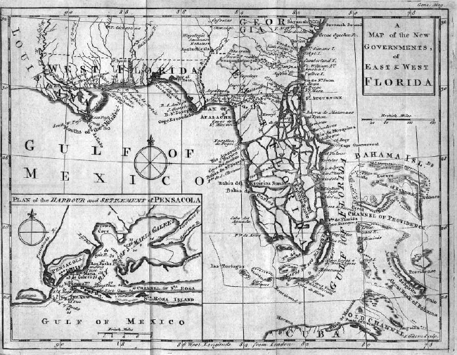
This English map from 1765 shows Florida split into an east section (governed from St. Augustine) and a western partition based in Pensacola. The map indicates that the English knew far less about Florida’s geographical details than their Spanish predecessors. Some thought Lake Okeechobee was linked to the St. Johns River. (Historical Society of Palm Beach County)
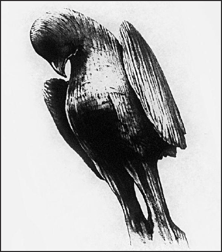
Those who thought the Calusa were a primitive people were in for a shock when archeologists found exquisitely carved statues like this four-foot eagle in the bottom of a pond in Fish Eating Creek, 12 miles west of Lake Okeechobee. It was probably part of a Calusa men’s lodge that was abandoned (due to disease and death?) by the 18th century and eventually fell into the pond. The pure water preserved it almost intact. (Florida State Archives)
The English ruled Florida for twenty years. Then, in 1783, as a political pawn in the Treaty of Paris, it was handed back to Spain in exchange for Gibraltar, the tiny but strategic fortress at the gates of the Mediterranean. But it didn’t matter much who owned Florida – especially the southern part. Everything below a slender farm belt in the northern tier was seen as a mysterious nether land of swamps, snakes and swarms of insects.
South Florida remained so for the next hundred years. But some events did begin to unfold in that northern tier that would spread to the south and change it forever.
First, the English weren’t at all reluctant to farm. Indeed, the English colonial’s ideal was the landed estate and gardens of a country gentleman back in Devon or Wiltshire. The Crown was eager to cultivate the possibility of crop imports, so the Privy Council made grants of up to 20,000 acres to be settled by white Protestant families. By 1774 it had issued 242 grants for 1,440,000 acres (averaging over 12,000 per recipient). Truth to tell, most of the grants represented frivolous political paybacks, about on a par with telling someone “You’ve just been awarded the wild land of Tasmania; now go forth, and by the way, lots of luck!”
Most of the recipients lacked the money to survey and settle. They kept their deeds in old trunks with about as much thought to them as we might give to a certificate for ten shares in an old Alaska gold mine that was never worked.
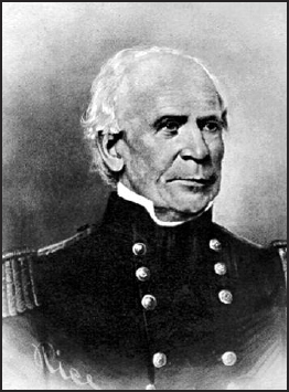
As Maj. Gen. Thomas Jesup headed the expedition that chased the Seminole Indians into south Florida, his only route through the wilderness led to a decisive battle in 1838 where the upper Loxahatchee River crossed today’s Indiantown Road. The area was still primitive in 1855 when army surveyors drew the map at right. (Historical Society of Palm Beach County)
But a few were serious, and they gave a hint of what would one day materialize to the south. Lt. Gov. John Moultrie had 14,300 acres and lived grandly at “Belle Vista,” outside the capital, St. Augustine. His records listed 180 slaves, rice barns, rice cleaning machines, 150 acres cleared for indigo, an orange grove, sugar-making equipment and 25,000 trees boxed for turpentine. Others in the St. Augustine in-crowd were boasting of growing everything from beans and potatoes to dates, olives, hemp and cotton. 10
The farther south one settled below St. Augustine, the more apt his livelihood would be linked to wild fields and forests. A summary of shipments from East Florida during 1766-68 names pine boards, oak staves, mahogany, shingles, tar, turpentine, deerskins and other hides.
The second major change during English rule was the arrival of a new type of Indian. As the nineteenth century dawned, northern Florida was already home to a growing number of Indians referred to collectively as Seminoles.
Seminole probably derives from the Spanish word, cimmeron, which means “outlaw” or “runaway.” That would hardly be accurate to describe the Creeks who had lived for centuries in Georgia, Alabama and the Carolinas until they were pushed off their lands at gunpoint by land-hungry white planters. In their forced migration south, the Creeks proved convenient allies of runaway slaves from southern states.
Since slaves had farming knowledge, they could provide the hunting-herding Creeks with crops in exchange for protection. Eventually, Africans worked their way into Creek society. And with intermarriage soon following, it became more accurate for whites to refer to all 5,000 or so high-cheeked, dark-skinned Afro- Indians in central Florida by one name. 11
Whites wanted Florida land for opportunity. Seminoles needed Florida land for survival. Whites could multiply their numbers quicker because they had shiploads of immigrants arriving every month. Confident of their greater force, they continued southward and inland. When the two forces would clash and whites were left dead, the local press would be full of headlines deploring “Indian massacres.” Horrified rural settlers would abandon their unprotected homesteads and flee northward.
The U.S. government was duly outraged. Congress had spent $5 million in 1819 to acquire Florida from Spain. Getting a return on the investment meant generating taxes on trade, which meant attracting settlers. If the taxpayers were scared off by Indian raids, Congress would look like a foolish gambler. When Andrew Jackson became president in 1829, much of his popularity sprang from his tough, aggressive campaigns as a major general in charge of the army forces in the First Seminole War a dozen years beforehand. What Florida needed, the old warhorse quickly concluded, was a strong military expedition to round up the Seminoles and pack them off in trains to the Indian Territories (today’s Oklahoma and Arkansas).
So began the Second Seminole Indian Wars. And, at long last, something happened in the land that would one day become Palm Beach County.
In January 1838 Maj. Gen. Thomas S. Jesup and roughly 1,500 men had pursued a large band of Seminoles to the eastern shores of Lake Okeechobee where they had suffered 25 dead and 111 wounded, only to have the enemy disappear into the saw palmetto. Bitter and bone-tired by then, Jesup learned that scouts had spotted some 300 Seminole warriors on high ground around some river called the Locha-Hatchee, an Indian name for “river of many turtles.” Against his better judgment, Jesup drove his men on through swamps that made their boots rot off so that soldiers had to wrap their feet with corn sacks. Sawgrass in the water and saw palmetto on the higher ground sliced at their arms and made their horses rear up with pain.
Another ambush and more loss of soldiers happened at the Loxahatchee, but Jesup also learned that his foe was even more tired and hungry than his men. The Indians sent a delegation to negotiate, and when approximately 500 Indian men, women and children were coaxed into the army camp on the promise of food and wyomie (whiskey), they were rounded up like cattle and sent off to the reservations out west. Another 160 fugitive slaves were sent back north.
But another 200 Indians had been all too wary of the army camp and melted into the Everglades. General Jesup had had enough, however. He wrote the War Department urging that the remnants be entitled to live in a land that “no white man would ever want” and “the interior of which we are as ignorant as the interior of China.”
By 1838 the government had already lost some 3,000 men and spent over $30 million (six times Florida’s purchase value) pursuing no more than 2,000 Indians. All but 200 had been captured and hauled off, but it wasn’t good enough for Jackson and the War Department. For another four years forts on what had become the “military trail” had sent out expeditions to round up Everglades Seminoles. 12
In the course of one search along the Hillsboro River, the troops came upon “Indian fields of sugar cane, corn and bananas...in cultivation.” Again, at a clearing on the edge of the Glades, they discovered two towns from former Indian times. “All were now overgrown with pumpkin, squash, and melon vines, occasional lima beans and Cuban tobacco,” the report read. On a nearby island the soldiers found patches of green corn and sugar cane in addition to the usual vegetable vines.” 13
They had discovered Palm Beach County’s first farmers. They had already discovered the gold that eluded the Spaniards.
Black gold.
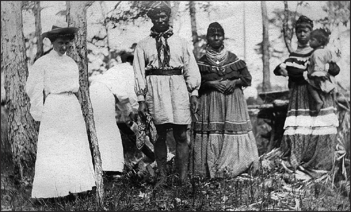
A Seminole family in their camp near Lake Okeechobee, 1906. (Historical Society of Palm Beach County)
By 1840 East Florida’s population had zoomed to 19,535 – up 123 percent from the census ten years before. But the seemingly impenetrable southernmost third of the territory counted absolutely no one. No doubt a few desperate souls dwelled therein – army deserters, debtors, Seminoles – who’d rather not be noticed or counted. Almost as reluctant were some sixty mosquito-swatting soldiers who Gen. Thomas Jesup left behind in Fort Jupiter, a crude wooden stockade on the Loxahatchee River whose mission was to keep the renegade Indians in their swampy Everglades refuge and punish anyone desperate enough to show himself.
In 1842 Congress decided to fill its southern population void by passing the Armed Occupation Act. In the Territory of East Florida it offered a quarter section of land to men who would settle south of a line running roughly from Palatka to Gainesville. They had to be able to bear arms because the law required them to settle at least two miles from a military fort. If they survived five years, they’d get title to the land.
Within a year 242 permits were issued from St. Augustine, the territorial capital. The 150-mile stretch from Fort Pierce to Biscayne Bay accounted for about 120 of the claims, many of which were never acted upon. 1
But it was a start.
In 1845 Florida became a state. And because one could find more wildcats than voters way down south, the legislature in faroff Tallahassee engulfed today’s Palm Beach County first, within barely-known Brevard County, and later within an even murkier mass called Dade County. The latter, encompassing today’s Dade, Broward, Palm Beach and Martin counties and with 7,800 square miles, was six times the size of Rhode Island and bigger than 3 of the original 13 colonies.
Settling the east coast meant being able to bring supply ships into ports, but the shoreline off upper Dade County was rife with reefs. If a ship cracked up, which was far too frequent, sailors were as good as dead unless they could stumble onto a freshwater spring and comb the beach for washed-up fish that could pass the smell test.
In 1849 the military decided to aid shipping and spur settlement by sending a young lieutenant colonel by the name of Robert E. Lee on a mission to chart the coastline of Florida and recommend likely spots for lighthouses. Jupiter was a priority because its coastline came closer to the Gulf Stream than anywhere else in Florida, and because treacherous reefs surrounded its narrow, silt-prone inlet.
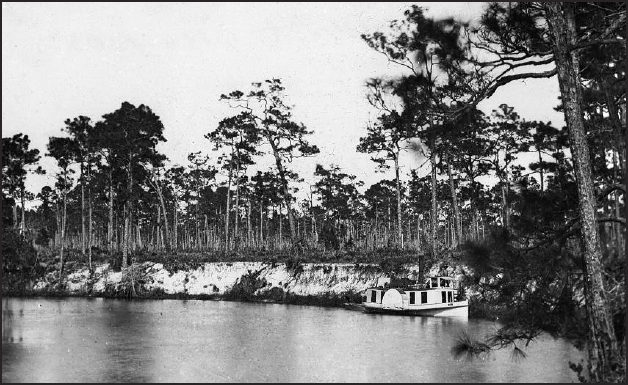
A small steamboat nestles in a bend in the upper Loxahatchee, probably not far from where boats are rented today in Jonathan Dickinson State Park. (Historical Society of Palm Beach County)
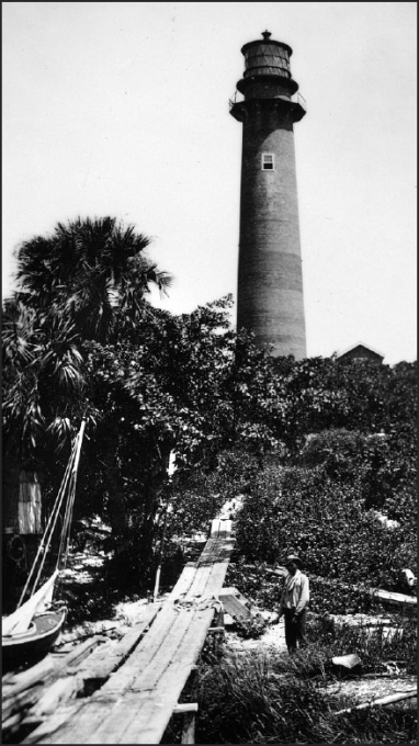
In 1871 Jupiter Lighthouse (and Fort Jupiter two miles upriver) were the only outposts of ‘civilization’ in south Florida except for Cape Florida Lighthouse on Key Biscayne. In 1880 the U.S. Census counted only 527 souls in a Dade County that encompassed 7,800 square miles. (Historical Society of Palm Beach County)
In 1853, when Congress created a U.S. Lighthouse Service, it also appropriated $35,000 to erect a light tower at Jupiter. The project called for a two-year timetable using a twenty-man crew, but Mother Nature had her own ideas. A sandbar had blocked the inlet at the time and the crew was forced to load some fifty shipments of bricks and equipment on shallow-draft barges at Fort Pierce. From there they would meander for some forty miles down the often-narrow, twisting Indian River to Jupiter.
Before long, the work crew had come down with a debilitating illness they knew only as “Jupiter Fever.” The soldiers at Fort Jupiter had it, too. This malaise, later known as malaria, combined with the fickle sandbar and periodic harassment by Indian forays from the Everglades to stretch the construction project to seven years. And almost as soon as the tower beamed its first light in 1860, the Civil War erupted and it went dark again for five more years.
Who was Palm Beach County’s first farmer? Probably the three lighthouse families, to the extent that they kept backyard gardens. But the story of serious commercial farming would begin in Lake Worth with Hannibal Dillingham Pierce and a hardy group of pioneers who soon joined him. In 1871 this romantic adventurer, living in Chicago, decided to follow his brother-in-law Will Moore to sunny Florida. He’d buy a small sloop and sail with his wife and seven-year-old son down the Mississippi and around to Florida’s west coast. His timing turned out to be fortuitous indeed. In October, just as the Pierces finished provisioning the sailboat, the Great Chicago Fire broke out and burned every ship in the marina to the waterline. Flames were literally licking at their stern as the family fled south towards the Mississippi.
Once they rounded the Gulf Coast into Florida’s Cedar Key, the Pierces sold the boat and rode to Jacksonville on a train nicknamed “The Mullet Special” because its main passengers were thousands of mullets netted, barreled and shipped north. After drifting down to Sand Point (soon to be named Titusville) in search of work, the family had just built a homestead along the Indian River when their own Great Fire broke out, destroying everything from their palmetto shack to the clothing hung up inside. The Pierces’ only good luck was that when they sailed south to Jupiter in search of refuge, they found that lighthouse Capt. James Armour could use an assistant.
So there Hannibal stayed, while he learned the demanding drudgeries of lighthouse maintenance, tried to rebuild his family’s rudimentary assets and regain a vision for their future.
Both happened quickly. In October 1872, the three keepers and their families experienced the bounty of Divine Providence, albeit in the form of someone else’s misfortune. A large merchant ship named Victor broke her prop in a storm. It fell back against the rudder, locking it in place and robbing the navigator of all control. Passengers and crew reeled on deck as the large ship drifted into the reefs outside Jupiter Inlet and began to break up. Although the lighthouse crew helped bring all survivors to shore, they were quick to jump back in their skiffs and begin snaring a flotilla of salvage that was washing over the bar and into the Jupiter (Loxahatchee) River. 2
Within a few hours, the Pierce family had a new start on life. One crate yielded fifty men’s suits. Another contained bolts of muslin. Hannibal proudly presented his wife Margretta with a Wilson and Wheeler sewing machine that had floated up in a large crate. Kegs of butter, rum and other supplies the families all divided – and all at a time when their twice-a-year shipments from the Lighthouse Service had been running low.
All this must have allowed Hannibal Pierce to dream ambitiously once again. Before and after the Victor adventure the lighthouse had played host to occasional travelers on their way to and from Lake Worth, seven and a half miles south of Jupiter Inlet. One could barely see its northern shore when standing on the platform atop the 105-foot tower, and reports reaching Hannibal’s ears were that it was the beginning of Eden.
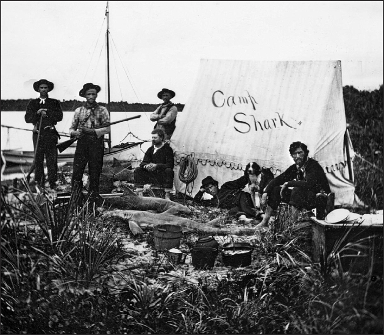
Bands of hunters and fishermen camped along Jupiter Inlet where condos stand today. This group hunted sharks for sport. (Historical Society of Palm Beach County)
Back then they called it “Lake Worth country.” William Lanehart had journeyed there to cut crab wood (used for making ornate walking canes) and he extolled its beauty. Pierce’s brother-in-law Will Moore had decided to accompany William Butler, a Virginian who’d been hired by a University of Rochester professor to collect skeletons of native birds and animals. Jesse Malden, a hunter from Georgia, had passed through with his wife and child, intent on a few weeks of hunting, and was supposedly camping somewhere on the lake.
Then came one Hiram F. Hammon, an Ohioan on a mission in search of his personal paradise. Well, when Hammon stopped by the lighthouse on his return, his ebullience must have been too much for Hannibal. As reported by his son Charles Pierce, who wrote the priceless Pioneer Life in Southeast Florida, Hammon announced he was going to stop in Gainesville, where the U. S. Land Office was headquartered, and stake a claim on Lake Worth.
Indeed, his was the first homestead claim filed in today’s Palm Beach County. As Charles Pierce noted:
All the talk about the beauties and wonders of Lake Worth, and of its rich hammock lands open to the homesteader, caused Father to change his mind about locating a new home. He was afraid if he waited too long all the best homesteads would be taken, so sometime in midsummer [1873] he announced his intention of giving up the lighthouse job in October and moving to Lake Worth. 3
By October, Pierce was ready to go. He had salvaged a lifeboat from the Victor and rigged it with two sails. And from the white pine that had washed up after the reef tore open its hull, he built a 12-foot tender that would tow behind the converted lifeboat.
But Pierce had no specific plan for dealing with a challenge that would vex Lake Worth settlers for the next twenty years. While the beautiful body of water beckoned like an awaiting bride, the aisle that led to the altar – the shallow, twisting Lake Worth Creek – simply petered out a thousand or so feet short of it. Indians were known to have tramped down a haulover for their canoes over many years, but finding it was a white man’s crapshoot.
To prove the point, it took Hannibal, Margretta and nine-year-old Charlie Pierce a week of probing dead-end creeks before they finally found the Indian trail. But any jubilance was quickly doused when a hurricane came howling that night. The three spent it huddled in an alligator crawl, lying on a spread of wet palmetto fans, trying to use the turned-over sloop as a shield from the battering wind. Food had all but run out, and that night, recalled Charlie, “Mother cooked our supper of fat pork with syrup and a cup of tea.” 4
The next day, amidst clear skies “when all nature seemed to be smiling and basking in bright sunlight,” Hannibal Pierce went out scouting and quickly returned with good news that he had reached the lakeshore. But hauling the sloop, with its heavy load of supplies and equipment, over the 300-yard trail would be impossible.
There was nothing to use for rollers and skids. The Indians used the stalks of the wild pawpaw as skids on which to slide their canoes. The very thin, hard, outer bark of the pawpaw stalk peels off, leaving a juicy undersurface over which the boat or canoe glides easily. At this haulover, however, there were no pawpaws. 5
The only option available to Hannibal Pierce was to leave the sailboat on the trail, hope to find brother-in-law Will somewhere in his specimen-collecting expedition, and have the two of them return to lug the sloop across. Meanwhile, he’d have to drag the 12-foot tender across on his own. Like a mule, he’d pull on the rope for twenty feet, sit until his heart stopped pounding, then pull again. As son Charlie wrote: “This violent exertion was particularly hard on him since he had very little to eat in the past twenty-four hours and not a wink of sleep.”
Mother and son went on ahead, and at last the tip of Eden appeared through the sawgrass.
We were at once struck by the peculiar color of the lake water. At first sight we thought it muddy; it seemed to be naturally opaque. Some years later it was found that this particular coloring was caused by the small amount of salt water that was mixed with the fresh water of the lake. The inlet was small and admitted only a small quantity of ocean water each day. As there was no fresh water emptying into the lake, only a seepage from the west shore from the swamps, the mixture of fresh and salt water was kept at even grade, hence the color. 6
The lake was nearly 23 miles long, and its 50 miles of shoreline had been scarcely trod by man. In 1866 one Michael Sears and his son George had sailed a schooner from Biscayne Bay to the Indian River and had found inlets only at Boca Raton and Jupiter. But on the way back, after a prolonged period of rain, they were some ten miles south of Jupiter and saw a swift, broad stream of dark fresh water pouring from an opening in the beach ridge.
When the tide changed, they decided to explore inside and found themselves on a lake with no end in sight from north to south. After a couple of miles southward they passed a log cabin on the eastern shore and met its occupant, who introduced himself with a thick German accent only as “Lang.”
Mr. Lang was correct and courteous, but no fount of information. As the sailors departed, he asked how the war was coming along.
“What war?” asked Michael Sears.
“Vy the Var Between the States,” said Lang.
When told it had been over for a year, the settler seemed astonished.
What Lake Worth’s first pioneer hadn’t volunteered is that he had come from Saxony, had been an assistant Jupiter lighthouse keeper at one point, and had been farming on the Indian River when the war broke out. When lighthouse keeper Joseph Papy had refused to darken the light so that Confederate supply boats could sneak up Jupiter Inlet undetected, Lang had been one of three men who had kidnapped Papy and stolen the lighthouse lens. As the war turned in the Union’s favor, Lang fled to the most remote place he could imagine.
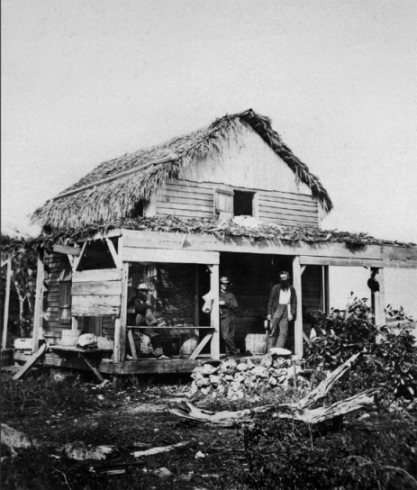
Hannibal Pierce’s first home, on Hypoluxo Island, was built from beached lumber and topped with a palmetto frond roof. That’s Pierce at right, leaning on one of the foundation posts. (Historical Society of Palm Beach County)
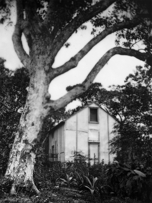
Valorous Spencer’s home along Lake Worth (1876) looks almost modern except for the fact that the walls were made entirely from canvas sails that had washed up on the beach. (Historical Society of Palm Beach County)
Now, with this liberating news, it wasn’t too long before Lang packed up and moved north, but not without bequeathing a small legacy. Lake Worth’s first settler just happened to be a horticulturist, and the carefully cultivated rows of plants and trees he left behind would give the first farmers an important jump-start.
7